- Thumbnail
- Resource ID
- ed351756-6f6a-11e9-8d7d-000d3ab6a624
- Title
- TM-BRB_Major Coastal Locations-1997-1:10000
- Date
- May 5, 2019, 2:21 p.m., Publication
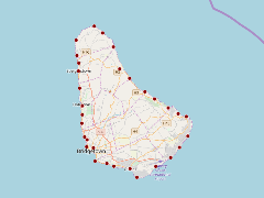
- Abstract
- This dataset highlights major coastal infrastructure and locations around the island of Barbados. This dataset was provided by the Coastal Zone Management Unit of Barbados ca.1997.
- Edition
- --
- Owner
- gridanode
- Point of Contact
- devrsgis@gmail.com
- Purpose
- --
- Maintenance Frequency
- None
- Type
- not filled
- Restrictions
- None
- None
- License
- None
- Language
- eng
- Temporal Extent
- Start
- --
- End
- --
- Supplemental Information
- No information provided
- Data Quality
- --
- Extent
-
- long min: -59.6478901376
- long max: -59.4298730748
- lat min: 13.0473537184
- lat max: 13.3346655239
- Spatial Reference System Identifier
- EPSG:900913
- Keywords
- no keywords
- Category
- None